

The Lois Creek Trail system in Kimberley today evolved out of horse logging operations in the area more than 100 years ago. In the early 1900s the creek and expanding network of logging roads were named after the daughter of the general foreman of Cominco at that time, Harry Gamble. Logs hauled by horses out of the Lois Creek watershed were used to build homes in Kimberley; they provided wood for local sawmills and employment for building contractors and tradespeople. Lois unfortunately died during the 1918 Spanish flu epidemic, but her namesake trail system flourished and is now a popular community recreational asset.
In the early days the Lois Creek trail system between Townsite and Meadowbrook evolved with generous community support. Members of the local Legion helped maintain part of what was known as the Legion Track (on what is now Legion Ridge), staging regular snowmobile races in winter and foot races in summer. In 1997, after more than 40 years of informal community use, and with the impending closure of the Sullivan Mine and a proposed new logging operation looming large, a group of local hikers under the leadership of Don Davies, a well-known adventurer and educator, recognized the recreational potential of the trails and formed a volunteer organization known as Friends of Kimberley Integrated Trail System (KITS). Volunteers began managing these trails for hiking and biking in summer, and for snowshoeing and cross-country skiing in winter. Routes were designated and trails named and maintained. In winter, a Nordic ski tracker was used to encourage cross-country skiing.
In 1998, conflicts began to emerge between recreational users and the proposed logging activities. With city support, KITS applied successfully to the Ministry of Forests to have the area designated as a provincial Forest Service Recreation area. Over the next few years fierce opposition from users of the Lois Creek trails forced mitigation of the planned logging operations in the area, and during that time KITS evolved into an organization known as Friends of Lois Creek (FOLC).
In 2003, the City of Kimberley adopted a Trail Network Master Plan that encouraged the development of an integrated trail network for the city. FOLC helped to ensure that the Lois Creek trail system was included in this plan, and subsequent funding was secured for enhancements to bridges and trails. In addition, Lindsay Park School began using the trails adjacent to the school for educational programs.
In 2005, FOLC applied to the Ministry of Forests, Lands, Natural Resource Operations and Rural Development to formalize the official designation of the Lois Creek Trail System under the provincial Recreation Sites & Trails BC network. That proposal was accepted in 2010, with the FOLC group coming under the umbrella of the Kimberley Trails Society (KTS), which now serves as site operator. On behalf of FOLC, KTS also negotiates an ongoing five-year License of Use and Occupation with Lois Creek Developments, a company that owns two parcels of Lois Creek land near the Centennial Hall Entrance to the trail system.

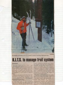
By 2012, approximately 80 new signs had been installed, significantly reducing the risk of getting lost in the network of trails. The following year a logging company, Canfor, submitted a proposal to the city to log trees killed by pine beetle infestations in Lois Creek, but after a hydrology report outlined the effects of logging in the Lois Creek watershed and reinforced the need for ongoing monitoring of water quality and flow rates, the logging plans were cancelled and a bridge was pulled, shutting off most motorized access from the Houle/Kimberley Creek Forest Service Road.
In 2014, the Tea Spot received a significant upgrade when carpentry students at the College of the Rockies built a timber frame structure over the picnic table using only wooden materials – dowels, wedges, and mortise-and-tenon joints. Over the years, the nine-kilometre Tea Spot Loop has emerged as a favourite destination with hikers, mountain bikers and cross-country skiers.
The founder of Friends of Lois Creek, Don Davies, unfortunately passed away in spring 2019 following a long illness. At the group’s annual general meeting in November, his son Mark chaired the meeting.
Ongoing monitoring of the Lois Creek and Kimberley Creek watersheds north of town is one of the best ways to support watershed management decision-making, according to web-based report being prepared for Mainstreams and Friends of Lois Creek in spring 2020. Using an innovative story-map format, Ryan MacDonald, principal hydrologist with MacDonald Hydrology Consultants Ltd., says in the report that the future of the watersheds will be driven by overarching factors such as natural disturbance and changes in climate.
The watershed assessment project was coordinated by Mainstreams, a local water conservation group, on behalf of Friends of Lois Creek with funding from the Columbia Basin Trust Community Initiatives Project administered by the Regional District of East Kootenay. FOLC and Mainstreams would like to acknowledge the substantial volunteer contributions of Ryan MacDonald.
In recent years the risk of wildfire has increased for the City of Kimberley, and in 2020 a new proposal by Canfor to commence logging operations in the Lois Creek watershed is being considered as part of ongoing wildfire mitigation activities. As well, Friends of Lois Creek continues to manage a multi-year program to reduce invasive weeds using goats, and to work with the Kimberley Trails Society in managing the outstanding trail system in this important community recreational asset.
Come on, all you “Townsite kids,” tell us about playing in the Gully or racing on the Legion Track when you were growing up. If you have a story to contribute – a personal anecdote, a favourite loop, or a cherished memory – please share it in the Comment Box below.
The Gully is the best! We played all the time down there, it was a never-ending source of adventure. Finding treasure like remnants of old go carts, cabins, horse stalls; just walking in a straight line for hours; that awesome time when a wind storm knocked down a ton of trees and made the ‘Ewok village’. Lots of danger too – bears, cougar, coyotes, getting lost. Sliding in winter, making forts, I could go on. Glad to see it’s still being taken care of